
Lac Lauzon to Lac Bleu: Loop hike in La Chapelle-en-Valgaudemar
If there’s one impressive valley ánd area for great hikes in France, it’s Valgaudemar in Écrins National Park. Hiking the loop trail Lac le Lauzon—Lac Bleu offers wildflower meadows, peaks all around (the famous Sirac below), impressive blue lakes, and fields to frolic. Here’s my guide on what to expect, how to get there, and when to go, so you’ll get the most out of it!

Looking back on the trail, Sirac standing tall and proud.
At a glance
Distance: around 6.4 km loop trail
Elevation gain: 534 meters
Hiking level: moderate
Average time: 3–5 hours, depending on pace
Trailhead: Refuge du Gioberney car park
Best time to go: June–Sept/Oct
Spot the full route on AllTrails.
How to get there
Getting here is pretty easy, and the road is already impressive. To reach the trailhead, navigate to Refuge du Gioberney in La Chapelle-en-Valgaudemar, located in the Écrins region. From Gap, it’s around a 1.5-hour drive. It’s a narrow road to the end of the valley, and you’ll pass several cute villages on the way. You can stop at a small bakery to buy some iconic Tourtons: a specialty from the Southern French Alps, especially this valley in the Hautes-Alpes. Think of them as little golden fried pillows. Traditionally, they were filled with mashed potatoes (sometimes mixed with onion or cheese), then deep-fried until crispy. They’re basically the local answer to "what if a dumpling and a doughnut had a baby?"
Anyway, moving on from food to the road again.
Start by following the signs for Valgaudemar Valley until you reach the village of La Chapelle-en-Valgaudemar. Continue toward Gioberney, and as the valley narrows, you’ll eventually arrive at the refuge.
Note: public transport options are limited! So driving is the most convenient option.
Trailhead
The hike starts at the Refuge du Gioberney, a scenic yet popular starting point. Remember that in peak season, the refuge's car park fills up quickly. Many people park alongside the road if there’s no spot left, but mind you it can get crowded.
To avoid the crowds, it’s best to arrive early. You can also consider staying overnight at the refuge for easier access to the trail at quieter times.
Start of the trail - about 10 minutes in.
What to bring
Water. There are no reliable water sources along the trail! Either fill up at the start or bring a filter for the lakes.
Snacks. Always a good idea.
Layers. The weather can change fast, so bring a light jacket, even if it’s warm when you set off.
Sun protection. There’s not much shade on the trail, although towards the end of the afternoon you’ll probably walk in the shadows. Do bring sunscreen, and perhaps pack a sun protection shirt.
Best time to hike Lac le Lauzon to Lac Bleu
The ideal time to hike this loop trail is between late May and September. By then, the snow has melted, and the trails are clear. July and August are the busiest months, attracting many hikers (lots of cars, and lots of day hikers on the narrow trails). If you prefer fewer people, consider June or September. Aim to arrive early to beat the crowds and secure your parking spot.
Autumn can be great as well, as colours are popping - orange, red, brown: all super impressive! Especially when the sun hits just right and it feels like you’re in a golden valley.
Hiking in late summer and early autumn
Hiking the lake loop in late summer into early autumn is a great option as well! If the conditions hold up, even October can be spectacular. As the leaves turn, the mountains are cloaked in incredible hues of red, orange, and gold. The landscape transforms entirely, offering an enchanted atmosphere, especially when the sunlight hits just perrrrfect.
As always in the mountains, weather can be unpredictable. With snowfall sometimes arriving by late September, the gamble pays off when the autumn colours are on full display. Towards winter, it gets a bit difficult to reach this spot. Often, the road is blocked by snow, rocks or landslides.
First impressions of the trail
First impression: holy moly this is crazy! As I mentioned already, the road up to the trailhead is impressive. I visited the area in different seasons, and every time I'm surprised how much the valley changes with the seasons. In the heart of summer (when I took these pictures), the trail was quite busy. Lots of day hikers. Although this area isn’t as famous as some other areas in the Alps, it’s easy to see why it’s a favourite location for those who know it.
Start of hike to Lac le Lauzon
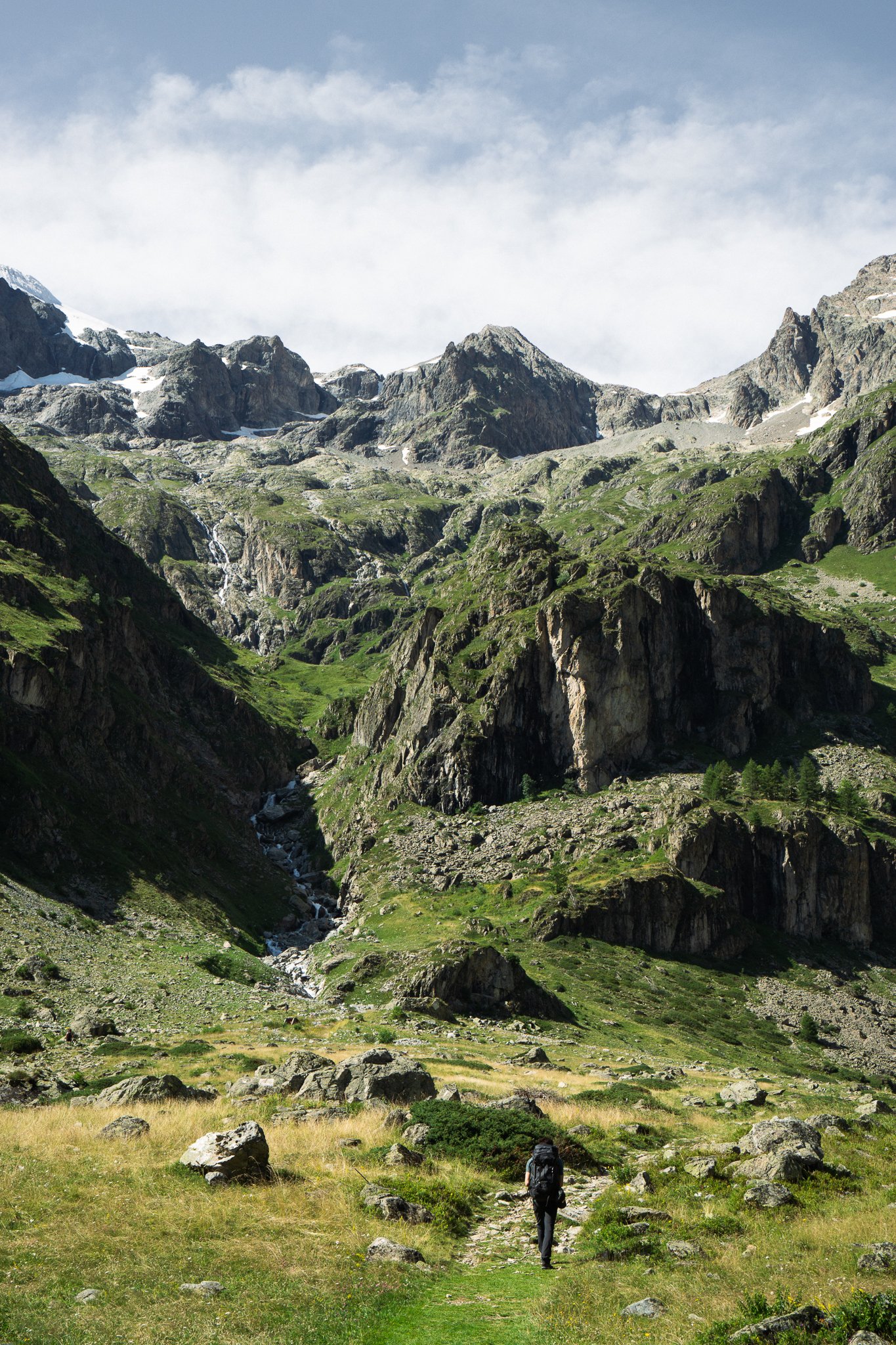
The first part of the trail is surprisingly gentle. It’s the kind of easy incline that lets you settle into a rhythm while offering views that make you stop to take it all in. You pass through alpine meadows that, in the summer, are blanketed in wildflowers. Yellows, purples, and whites add colour against the green and rocky terrain. One of the trail’s early highlights is the sight of the Sirac peak, one of the park’s iconic summits. The Sirac’s sharp, imposing silhouette really sets the scene.
As you get higher, the trail starts to open up. That’s when you get treated with some overwhelming views of the Cirque du Gioberney. It’s easy to feel small here, in the best way possible.
After a while, you reach Lac le Lauzon. A small and peaceful lake reflecting the grandeur of the surrounding mountains. It offers a perfect spot to chill and frolic, and soak in the views.
From Lac le Lauzon to Lac Bleu
After a snack and a rest, you continue toward the second lake, Lac Bleu. This is where the trail gets a bit steeper and rockier. It is still fairly easy, but I do understand why this hike is rated ‘moderate’ overall.
When you crest the last hill and catch sight of Lac Bleu, make sure to take your time here. It’s so lovely! The water is an impeccable shade of blue. A deep turquoise that fits beautifully with the greens.
My tip: Start early in the morning to avoid the midday crowds, or choose to go at the end of the afternoon if you want to catch the sunset vibe up the mountain. Hiking during sunset means you’ll have this spot to yourself. Take plenty of time for breaks at both lakes. You’re gonna want to linger, trust me.
The descent
The descent is straightforward, though you want to watch your footing on the steeper parts. Along the way, you’ll pass a trail that leads to the Refuge du Pigeonnier. An alpine refuge perched higher in the mountains. It’s a popular spot for those who wish to extend their adventure with an overnight stay. For day hikers, it’s worth the short detour and grabbing a quick meal before heading back.
About Écrins National Park
Écrins National Park is one of France’s most remarkable protected areas. It sits in the French Alps, between Grenoble and Gap, and is basically a giant playground for mountain lovers. Known for its dramatic alpine landscapes, diverse ecosystems, and impressive peaks, including the famous Barre des Écrins. Around 40 glaciers still hang on here. They’re retreating, but still very photogenic. And no big cities nearby = some of the darkest skies in France! Perfect spot to stargaze with a flask of génépi (local herbal liqueur, very sweet, very nice).
The National Park covers about 925 km² of protected land (so, bigger than New York City times 10). It’s split into two regions:
Western Écrins
Eastern Écrins
The western Écrins is particularly accessible for hikers, with four distinct areas:
Oisans: this is the “classic” Écrins zone. Think jagged peaks, glaciers, and rock walls. It’s the stomping ground for mountaineers but also has legendary hiking routes like the GR54. Villages like La Grave and La Bérarde are little basecamps for adventures.
Valjouffrey: more hidden and intimate. Known for its alpine meadows bursting with wildflowers in summer, plus tons of chamois and ibex. If you like peaceful trails with fewer people, this valley is gold.
Valgaudemar: steep walls, glaciers, and waterfalls. It’s dramatic and perfect if you want that jaw-dropping, postcard-style scenery. You feel tiny walking here. Exactly what I usually go for.
Champsaur: this is more the ‘soft’ area. Think rolling valleys, forests, and open views. It’s more “pastoral Alps” than raw granite walls. Great for families, cyclists, and people who want hikes without feeling like they’re training for Everest.
Final thoughts
This place offers something for every nature lover, from casual walkers to experienced mountaineers. Along the way you’ll probably meet the locals too: marmots (tons of them), ibex, and even golden eagles circling above.
I hope this guide gives you a head start for your own adventure in Valgaudemar, especially the Lauzon – Lac Bleu loop. Got questions about the trail? Drop them in the comments — happy to help.
See you out there!